CLIMB-ON MAPS
  • Home
  • Buy!
  • Maps
    • C-YA - Hiking Maps
    • City of Rocks, ID - Climber's Map
    • Joshua Tree, CA - Climber's Map
    • Red Rock Canyon, NV - Climber's Map
    • Smith Rock, OR - Climber's Map
  • Map Details
    • Quality
    • Map Elements
    • Methodology
    • Environment
  • About
    • Media Coverage
  • Calendar
    • Previous Input Events
  • Blog
    • Meet Our Tools >
      • GPS Units
      • Lifeproof Phone Cases
      • The Tiger - aka Tankenstein >
        • The Tiger Gets Gutted
        • Rebuilding the Tiger >
          • Cold Food Storage
          • Bouldering-pad-bench
          • Insulation and Vent Fan
          • Quick Fixes
          • The Bed
      • Ultralight Exposure Protection Gear
    • For the Ladies >
      • Cry
      • Getting Women Climbing Outside
      • Women's Resources
    • Red Rock Canyon, NV >
      • Camper Van Epic in Vegas
      • Mapping with Lady Lockoff
      • Vegas-epic-2
      • Vegas Mini-epic 3: Really?!?
    • Joshua Tree, CA >
      • Caterpillars! Van Rescue!
      • Gram Parsons' Logbook
      • Oh Shi*! Bees!
    • Hmmm or Haha >
      • Althea Crag & Mapping Dog
      • Exposure!
      • Realities
      • Silliness
      • Utterly Heinous Approaches
      • Podcast Interview: Ogden OUtdoor Adventure
  • Contact
    • Feedback
  • Retail Stores

Map Elements

The areas for our first maps are:

  • Red Rock Canyon, NV
  • Smith Rock, OR
  • Joshua Tree, CA (To be released in early 2018 - keep an eye out for earlybird discounts!)
Here is what Climb-On maps provide:
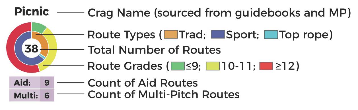
Quick visual reference of the number of climbs and grade distribution at a crag or wall.
  • Plan your climbing day based on the type of climbing you want to do (e.g. sport or trad) and the difficulty.
  • At a glance you can tell if an area has a concentration of the type of climbs you want and if the approaches are close, far, easy, or difficult.
  • We have the most comprehensive list of route data, compiled from multiple guidebooks AND Mountain Project (MP)!
Picture
  • Professional and accurate GPS mapping of climber's approach trails, walk-off trails, and locations of climbing walls. (Map excerpt: Red Rock Canyon, NV - Black Velvet, Whiskey Peak)
Picture
  • Orientation photos, notes, and visual cues to help keep you headed in the right direction. (The colored arrows in the map correspond with the trails and and their color-coded difficult ratings.)
Picture
  • Quick visual reference for trail difficulty.
    • Trail difficulty is oriented towards climbers (who tend to have a high tolerance for adversity).
      • Easy - Can range from a flat "cruiser" to what many lay-hikers might consider "moderate."
      • Moderate - Conditions become more challenging such as hilly, steep, having to route-find, some boulder-hopping.
      • Strenuous - These are steep and difficult trails with one or more of the additional following conditions: loose dirt, loose scree or talus, requires use of hands (may include class 3 and/or 4).
      • Ass Kicking - The next level up. You will probably say "daaamn!" or maybe "uggghh" at the end of this one.
      • Soul Crushing - Take an ass-kicking trail with multiple challenging conditions, then add distance + repeated points of significant/scary exposure + additional very difficult conditions like thick thorny brush and time-sucking route finding. Makes you want to curl up in the fetal position and take a nap.
Picture
  • Quick visual reference for points and level of exposure (i.e. potential for injury if a fall occurs).
    • Exposure icons are included in areas where we encountered significant exposure. (Significant exposure is defined as: A fall of ~ 15 feet or greater. We also considered the fall zone - sharp rocks versus bushes.)
    • A lack of an exposure icon does NOT mean there is no exposure. Some form of mild exposure is common on many climbing approach and walk-off trails.
    • The difference between broken bones and major damage is that a "broken bones" fall may be able to self-evacuate. A "major damage" will likely need to be rescued.
Picture

  • More details on quality
  • Details on methodology

Menu

About
Blog
Buy
Contact/Stay Informed
Environment
Maps
Quality
© COPYRIGHT 2018. ALL RIGHTS RESERVED.
  • Home
  • Buy!
  • Maps
    • C-YA - Hiking Maps
    • City of Rocks, ID - Climber's Map
    • Joshua Tree, CA - Climber's Map
    • Red Rock Canyon, NV - Climber's Map
    • Smith Rock, OR - Climber's Map
  • Map Details
    • Quality
    • Map Elements
    • Methodology
    • Environment
  • About
    • Media Coverage
  • Calendar
    • Previous Input Events
  • Blog
    • Meet Our Tools >
      • GPS Units
      • Lifeproof Phone Cases
      • The Tiger - aka Tankenstein >
        • The Tiger Gets Gutted
        • Rebuilding the Tiger >
          • Cold Food Storage
          • Bouldering-pad-bench
          • Insulation and Vent Fan
          • Quick Fixes
          • The Bed
      • Ultralight Exposure Protection Gear
    • For the Ladies >
      • Cry
      • Getting Women Climbing Outside
      • Women's Resources
    • Red Rock Canyon, NV >
      • Camper Van Epic in Vegas
      • Mapping with Lady Lockoff
      • Vegas-epic-2
      • Vegas Mini-epic 3: Really?!?
    • Joshua Tree, CA >
      • Caterpillars! Van Rescue!
      • Gram Parsons' Logbook
      • Oh Shi*! Bees!
    • Hmmm or Haha >
      • Althea Crag & Mapping Dog
      • Exposure!
      • Realities
      • Silliness
      • Utterly Heinous Approaches
      • Podcast Interview: Ogden OUtdoor Adventure
  • Contact
    • Feedback
  • Retail Stores
✕